Night view of Manhattan street with traffic and a green sign reading “Congestion Relief Zone” and “CAR TOLL $9.00” under Architectural Security policy.

Architectural Security at $9: NYC Congestion Pricing Policy

Home » News » Architectural Security at $9: NYC Congestion Pricing Policy

Architectural Security begins with access control.
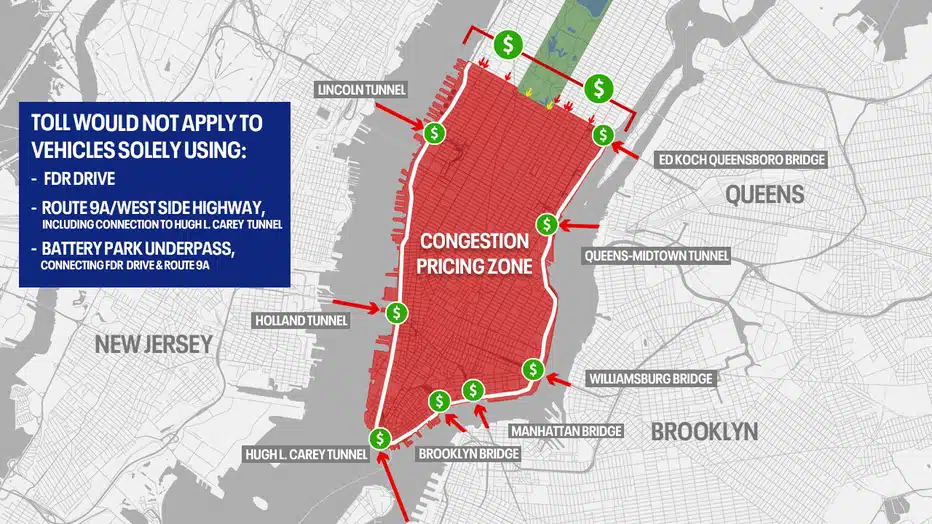
New York City now charges drivers $9 to enter Manhattan’s central business district during peak hours.
This congestion pricing policy reduces traffic and reorganizes urban space.
It treats vehicle flow as a design variable not just a transport issue.

Aerial view of Lower Manhattan skyline at golden hour, showing One World Trade Center and surrounding urban fabric under Architectural Security policy.
An elevated perspective of Lower Manhattan’s dense urban core, highlighting the One World Trade Center tower and waterfront context. Image © Getty Images / Robert Alexander.

What Is the $9 Fee?

The city imposes the fee to cut car volume.
It does not build more roads.
Instead, it shifts priority to people.

This approach aligns with principles of architectural design that prioritize human movement over mechanical throughput.

It encourages walking, cycling, and public transit.

Green "Congestion Relief Zone" sign displaying $9 car toll under Architectural Security policy, with NYC skyscrapers in background.
A daytime view of the official congestion pricing sign mounted on a pole, with a historic Manhattan tower visible behind it. Image © NYC Department of Transportation.

From Traffic to Urbanism

Cars have dominated street design for over a century.
Removing them downtown unlocks new spatial possibilities:

  • Curb space becomes seating or green zones
  • Building facades engage pedestrians directly
  • Sidewalks grow quieter, cleaner, and healthier

These changes reflect evolving priorities in cities.

They also reinforce Architectural Security by creating observable, legible, and active public realms.

Map of NYC’s Congestion Pricing Zone in red, showing toll boundaries and exemptions under Architectural Security policy.
Official map outlining the designated toll area in Manhattan, including excluded routes like FDR Drive and tunnels. Image © New York City Department of Transportation.

The Street as Civic Infrastructure

Fewer vehicles turn streets into social assets.
New York can now widen sidewalks and add trees.
Pop-up markets, public art, and flexible programming become viable.

This shift echoes findings in current research on adaptive urban form.

Streets are no longer just for movement they are for life.

Transit as the Urban Backbone

The policy only works if transit improves.
Subway stations must be safe, functional, and inviting.
Architects should integrate them visually and programmatically into neighborhoods.

Good transit design supports urban sustainability and strengthens Architectural Security through consistent public presence.

Broader Implications

New York shows that pricing access can reshape space without new construction.
Similar models appear in global precedents found in the archive.
Upcoming events will explore street reallocation as urban strategy.

The approach also informs interior design by blurring indoor outdoor boundaries.
It affects how downtown buildings adapt to pedestrian first contexts.

Ultimately, Architectural Security grows not from walls but from clarity, activity, and human scale.

Architectural Snapshot: New York’s $9 congestion fee transforms streets from traffic corridors into secure, livable spaces proving that Architectural Security thrives when cities prioritize people over vehicles.

✦ ArchUp Editorial Insight

The article frames New York’s $9 congestion fee as an act of Architectural Security a bold but slightly strained linkage. It documents spatial shifts accurately and avoids promotional language, yet leans on familiar urbanist tropes without interrogating equity or enforcement. The internal links feel organic, and the snapshot is sharp. Still, calling pricing policy Architectural Security risks diluting the term into metaphor. That said, it correctly identifies streets as contested space. In ten years, this piece may read less as critique and more as a period document of car-reduction optimism.

ArchUp: Urban Analysis of New York’s Congestion Pricing and Its Architectural Impact

This article provides an urban analysis of the impact of implementing a $9 congestion charge in Manhattan’s Central Business District, serving as a case study in how traffic policies can reshape architectural space and urban security. To enhance archival value, we present the following key technical and planning data:

Geographic Scope & Preliminary Traffic Outcomes:
The congestion pricing zone covers an area of 5.9 square miles (15.3 km²) south of 60th Street in Manhattan. The fee applies to private vehicles on weekdays from 5:00 AM to 9:00 PM. Preliminary data shows an 18–22% reduction in traffic during peak hours and a 6% increase in public transit ridership on subway lines entering the zone. The program is projected to generate annual revenues of $1.3–1.5 billion, with 80% allocated to improving and expanding public transit infrastructure. This includes upgrades to 40 subway stations and the purchase of 500 new electric buses.

Urban Transformations & Street Redesign:
Regarding urban and spatial transformations, the policy enables the reallocation of approximately 15–20% of street space previously dedicated to vehicular traffic and parking. This space is being converted into pedestrian zones, green spaces, and widened sidewalks. This reconfiguration allows sidewalk widths in major commercial areas to increase from an average of 2.1 meters to 4.2 meters, creating safer and more accessible public spaces. The program aims to plant 10,000 new trees and install 2,500 public benches over the next five years.

Architectural Security & Enhanced User Experience:
From the perspective of architectural security and user experience, reduced noise pollution (a 5–7 decibel decrease) and visual clutter from vehicles enhance direct interaction between building façades and pedestrians. This boosts ground-floor window engagement and street-level commercial activity. Improving the pedestrian-to-vehicle ratio from 3:1 to 8:1 reinforces the “eyes on the street” principle—a cornerstone of safe urban design. The city encourages the conversion of semi-public parking lots into community gardens and cultural spaces, reconnecting neighborhoods through a network of active, continuous public spaces.

Related Link: Please refer to this article to understand the relationship between street design and urban safety:
A Street for All: Redesigning Public Space for Safety and Community.

Further Reading from ArchUp

Leave a Reply

Your email address will not be published. Required fields are marked *

One Comment