2005: My Graduation Research on a Site That Became Part of the Grand Mosque Courtyards


This archival study examines the vertical development of Jabal Turk, a mountain formerly located near Makkah’s Grand Mosque. Originally a university project, it analyzed how mountainous topography could support urban expansion and pedestrian movement. The work addressed the high economic value of land based on proximity to the sanctuary.
The documented site has since been transformed into the northern courtyards of the Grand Mosque. By recording the area’s original informal structures and steep terrain, the study serves as a historical reference. It highlights the transition from natural mountain masses to dense urban spaces serving a global religious center.
Revisiting a 21-Year-Old Study of Jabal Turk (Jabal Hindi) in Makkah
A Study of Vertical Development in Makkah’s Central Mountainous Fabric
Original study by Ibrahim Joharji
Graduation Project, Umm Al-Qura University — supervised by Prof. Abdul Hamid Al-Bas
Original site: Jabal Turk, popularly known as Jabal Hindi — within the first ring road of the Central Area of Makkah
Archived and published by ArchUp, 2026
A Note on This Document
This study first existed as a graduation project completed nearly two decades ago at Umm Al-Qura University, examining the potential development of Jabal Turk, popularly called Jabal Hindi, within the mountainous fabric of Makkah’s central area beside the Grand Mosque. ArchUp publishes it now not as a student exercise revisited, but as a primary source worth removing from the drawer, because the questions it raised about topography, vertical development, and the price of proximity to the Haram were being asked by its author at the very beginning of his professional path, and because the site it studied no longer exists in the form it described.
The value of the document is twofold. It records, in the plans and analysis of its own time, a real place inside the most sensitive urban zone in Makkah before the wave of transformation that has since remade it. And it establishes, without exaggeration, that the concerns now shaping the debate over Makkah’s mountains, how to use vertical extension, how to move pedestrians to the sanctuary, how to weigh investment against topography and heritage, were present in this author’s work from the outset. What follows is that study, lightly edited for publication and set in its present context, with its original drawings preserved as archival figures.
Where the mountain once stood, pilgrims now pray. The site of this study lies today within the northern courtyards of the King Abdullah expansion of the Grand Mosque. That single fact is the reason the study deserves to be read.
A Note from the Author
In 2005, during my final year of architecture at Umm Al-Qura University, I had to choose a site and a subject for my graduation project.
I chose Makkah.
More specifically, I chose an old and largely unplanned urban area on Jabal Turk, commonly known as Jabal Hindi, close to the Grand Mosque. At the time, the mountain was still occupied by a dense fabric of houses, narrow paths, steep slopes, and the kind of incremental urban growth that had developed over many years around the central area of Makkah.
My graduation proposal was to study how part of this difficult mountainous fabric could be redeveloped and to test the possibility of introducing a hotel project within it. Before designing the building itself, the university required us to undertake an architectural and urban research study. That research became the document reproduced here.
I was interested in a question that seemed very practical at the time: how should an architect deal with a mountain located only minutes from the Ka’ba, where land value, pedestrian movement, topography, accommodation, infrastructure, and the enormous seasonal pressure of pilgrims all meet within the same piece of ground?
I was also from Makkah. These mountains, streets, slopes, and the changing edges of the Haram were not abstract planning subjects to me. They were part of the city I knew. Looking back, I can see that many of the questions that continued to interest me later as an architect — the relationship between architecture and place, the economics behind urban form, movement through difficult terrain, and the particular conditions that shape Makkah — were already present in this student work, even if I did not yet have the language I would use for them today.
I did not return to this study because I believed a graduation project from 2005 needed to be republished.
I returned to it while going through old architectural files.
What I found was no longer simply a university research document.
It had become a record of a place that had disappeared.
The photographs, maps, planning studies, development proposals, and observations in these pages capture Jabal Hindi and its surroundings at a particular moment in the history of central Makkah. The site I was studying for possible architectural development would later undergo a much more fundamental transformation. With the expansion of the Grand Mosque, the former urban fabric was removed, and much of this area became part of the expanded northern courtyards associated with the King Abdullah expansion.
The project I once imagined there was never built.
The mountain itself followed a different destiny.
Where I once studied slopes, housing, access, density, and the possibility of a hotel, pilgrims now move and pray within an expanded sacred precinct.
That change is precisely why I decided to publish the study in 2026.
I have kept its original character deliberately. It was an academic study produced by an architecture student for a graduation project, using the information, planning documents, photographs, assumptions, and development proposals available at that time. It should therefore be read as a document of 2005, not as a contemporary planning assessment of Makkah.
Twenty-one years later, some of its numbers are obsolete. Some of the projects it described as proposals have since been built. Some assumptions were overtaken by decisions far larger than the study itself.
But the site, the drawings, and the questions remain valuable.
For ArchUp, publishing this document is therefore less about preserving one student’s graduation work than preserving a small piece of the architectural memory of Makkah: a record of a mountain and an urban fabric as they existed before one of the most significant transformations of the central area.
For me, it is also an unusual opportunity to meet an earlier version of my own architectural thinking.
I was still a student.
But I was already looking at Makkah.
Ibrahim Nawaf Joharji
Architect
Original research completed at Umm Al-Qura University, 2005
Revisited for the ArchUp Primary Source Archive, 2026
1. Introduction: A City Centre Built on Mountains
A city centre is one of the most telling markers a place can have. It carries the cultural and economic identity of a people, and it is usually the first image an outsider forms of a country. Yet it is rare, almost unheard of, for a city centre to be defined by mountainous topography without the city itself sitting on a mountain. Makkah is the exception. Its central area is set among the surrounding heights, and this is not incidental. It is the defining condition of everything built here.
The strange fact is that these heights are among the most expensive real estate in the Kingdom, and arguably in the Middle East, even though the resident density outside the seasons of Hajj and Umrah is lower than in other cities that carry comparable land values. The reason is not the resident alone. It is the site itself, and what the site means to Muslims everywhere. Value here is not generated by population. It is generated by proximity to a single point, the Ka’ba, and it falls away with every additional minute of walking distance from the Haram.
From this condition arises the purpose of the original study. It proposed investment alternatives for one of the most significant kinds of project the area could receive, and it proposed to absorb a share of the visitors by using the vertical extension of the land in developing a defined sector of Jabal Turk, a mountain lying within the first ring road of the central area of Makkah. The premise was simple and, in hindsight, prescient. If the ground around the Haram is finite and priceless, then the mountain is not an obstacle. The mountain is the last remaining direction to build, which is upward.

Figure 1. The study site and the ring of mountain masses around the Grand Mosque, marked on the central area of Makkah. From the original study.
2. The Geography and Climate of Makkah
Makkah and the holy sites lie on the northern edge of the tropical belt, at the meeting point of the Tihama plain and the mountains that enclose the city on every side, which is why the city is formed from a series of valleys that open toward the sea to the west. The city sits in the valley of Ibrahim, held between two converging chains of hills, and it rises some three hundred metres and more above sea level, on ground that counts among the most difficult geological formations in the region, most of its rock hard granite of the Arabian Shield.
Topography
The terrain divides into three bands running north to south. The western section rises between two hundred and two hundred and fifty metres, with some peaks reaching four hundred. The central section rises above three hundred metres and carries the historic mountains, Jabal Khandama at around four hundred and twenty metres, Jabal Abu Qubais at three hundred and seventy two, Jabal Qu’ayqi’an at four hundred and twenty seven, and Jabal Thawr climbing to seven hundred and fifty nine. The eastern section exceeds four hundred metres, with peaks above eight hundred, including Jabal al-Tariqi east of Mina at some nine hundred metres, the highest of Makkah’s mountains and the holy sites.
Climate
Makkah records some of the highest maximum temperatures of any monitoring station, and its annual average is among the highest in the world, near thirty degrees, a consequence of its distance from any large body of water. Summer exceeds forty eight degrees, winter falls to around eighteen, and the air moves slowly because the Sarawat mountains enclose the city and hold it in a transitional zone between the range and the coastal plain of the Red Sea. Humidity runs inversely to heat and stays generally low, its recorded high around fifty seven percent and its low near thirty two. Rain is rare and irregular, but when it falls heavily it produces floods that have historically swept everything before them and entered the Grand Mosque more than once, which is a design constraint no plan for this valley can ignore.
3. The Mountain as a Global Development Question
The original study set its local site inside a wider frame that was live at the time it was written, the international attention then being paid to mountain regions. The United Nations had declared an International Year of Mountains, and the movement around it argued that mountain areas carry unique problems and demand specific rather than generic solutions, that mountain development deserved a place on the global map, and that awareness had to be converted into concrete measures rather than left as sentiment. The study drew a line from that global conversation to a local truth, that Makkah’s mountains were not merely scenery or obstacle but the largest thermal and spatial reserve the city possessed, and that the informal settlements climbing their slopes were a social and urban problem requiring urgent and careful treatment rather than simple clearance.

Figure 2. The first and second ring roads as principal determinants of the commercial and tourist zone of the central area. From the original study.
4. The Study Area: Reading Jabal Turk As It Was
The study area lay to the south west of the central area, inside the first urban ring, and the first phase of the work was a full reading of its existing condition drawn from prior reports, survey, and field investigation. The terrain was severe, with slopes that reached beyond fifty degrees in places, and these slopes were treated not as a defect to be erased but as the primary feature of the site, something to be employed for maximum benefit rather than flattened.
Urban structure and building condition
Residential use dominated the area. Much of it was informal, built as single storey structures using load bearing walls, while a large share of the newer building rose to two and three storeys. Services were thin, with a single health centre for a population that plainly needed more, and the road network showed sharp differences in service between the well connected edges and the isolated interior, a direct consequence of the topography. The visual fabric fell into two families, the regular gridded pattern of the planned northern and north eastern parts, which gave a clear mental image of place, and the informal pattern of interlocking houses and temporary zinc structures, which resisted any legible visual order.
Development indicators
The analysis concluded that roughly twenty percent of the area was genuinely suitable for urban development, enough to absorb the existing shortfall in services and to provide for future residents, while other zones resisted development because of their mountainous nature and could be reached only through deliberate physical study. The constraints were named plainly, water shortage, drainage problems, narrow streets, absent parking, difficulty of extension to the north and west. And the single strongest indicator was stated without decoration. The optimal direction of investment growth was toward the Haram, because nearness to the sanctuary gave the area an investment character that no other factor could match.
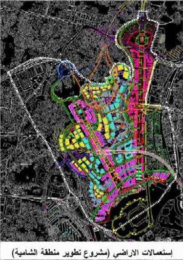
Figure 3. Land use analysis of the study area, from the original survey boards of the project.
5. The Projects on the Neighbouring Mountains
The study read the site against the wave of development then rising on the mountains around the Haram, and used those projects as references for scale, capacity, and intent. At the time of writing they represented the new model of large scale development encircling the sanctuary, and the study treated them as the context its own proposal would have to answer to.

Figure 4. The mountain masses around the Grand Mosque named on a single context map: Jabal Omar and Jabal Al-Ka’bah to the west and north, Ajyad Citadel and Jabal Khandama to the south. From the original study.
Jabal Omar
Jabal Omar was described as the embodiment of the future vision for developing the areas adjoining the Grand Mosque, and as the second largest urban project after the expansion of the Haram itself. Its stated aims were to build up the land overlooking the sanctuary, to own, develop, manage, invest, and lease the properties facing it, and to secure a higher return for the surrounding real estate. It occupied some two hundred and thirty thousand square metres to the west of the Haram, bounded on the east by Ibrahim al-Khalil Street. Its pedestrian spine was designed so that the longest distance a pilgrim would walk from the edges of the project to the Grand Mosque would not exceed one hundred and fifty metres, and its architecture leaned on reviving the built heritage of Makkah through shaded arcades, mashrabiyat, rawashin, and stone cladding.

Figure 5. Master plan of the Jabal Omar project, studied as a reference for scale and pedestrian strategy. From the original study.
Al-Shamiyah
The Al-Shamiyah development aimed to build an urban environment fitting the standing of the sanctuary, to integrate with the structural plan of the central area, and above all to restructure the road network so that the courtyards of the Haram could be widened to hold more worshippers. It proposed extending the sanctuary courtyards to the north and north west by a depth of around one hundred and twenty metres, while respecting land and building boundaries and the natural terrain to avoid sharp gradients. Its planning conditions were exacting, minimising cut and fill in the natural level of the land, avoiding any harm to groundwater and especially to the well of Zamzam, and holding road gradients below eight percent. Its inner courtyards were to be designed in continuity with the Haram courtyards, oriented to the qibla and kept in visual connection with the sanctuary so that prayer could be held within them.
Abraj Al-Bait
Abraj Al-Bait was recorded as a government project of major investment scale rising directly opposite the Haram, and the study preserved its projected aerial view as one of its figures. It stood, in the original document, as the emblem of the vertical, high density model the whole central area was moving toward.
6. Capacity and the Logic of Density
The study worked with concrete figures for what development beside the Haram should hold, drawn from the standards applied to the neighbouring projects. Population density in the reference zone was set at between one thousand and one thousand two hundred people per hectare, split roughly thirty percent permanent residents and seventy percent visitors, and of those visitors around forty percent housed in hotels and thirty percent in residential apartments. A third of the total area was reserved for public plazas and pedestrian routes, developable land was to be no less than half the total, and total built area was calculated at thirty six square metres per person in hotels and sixteen per person in residences. Pedestrian flow was sized for a movement of five hundred thousand people per hour to and from the Haram, with combined pedestrian route widths of no less than one hundred and twenty metres, and no single journey to exceed twenty minutes whether on foot or by mechanised pedestrian transport. These numbers describe a district engineered less around living than around the movement and accommodation of a vast, pulsing multitude, which is the true design problem of everything built beside the sanctuary.
7. What Became of the Site
The study is published now with one essential piece of present context, stated plainly and without embellishment, because it is what gives the document its weight. The area that this graduation project proposed to develop no longer exists as a mountain fabric of informal houses and steep lanes. It lies today within the northern courtyards of the Grand Mosque, absorbed into the third Saudi expansion known as the King Abdullah expansion, which was launched in 2011, inaugurated in 2015, and which extended the sanctuary and its courtyards across the districts to the north and north west, through Shamiyah and Jabal Hindi toward Jabal al-Ka’bah, with pedestrian tunnels, one of them driven directly through Jabal al-Hind, linking the new courtyards to the Mosque.
The reference projects moved in parallel. Jabal Omar, studied here as a proposal on paper, was built and completed, a dense cluster of hotel towers facing the sanctuary. Al-Shamiyah, which the study read as a development district, became in effect the northern courtyards expansion of the Haram itself, its fabric cleared to widen the space of prayer exactly as the capacity logic implied. And Abraj Al-Bait was completed and crowned with a great clock that did not appear in the plans the study preserved, a vertical landmark now looming over the sanctuary it was built to serve.
This is why the document matters. A student stood on Jabal Turk two decades ago, measured its slopes, counted its houses, weighed its impossible land value against its severe terrain, and asked how a mountain beside the Haram should be used. The answer history gave was more total than any plan on his drawing board. The mountain became a courtyard, and the pilgrims now walk across the ground he once surveyed. The study is the memory of a place that was studied before it was transformed, and that is a rare and serious thing for any archive to hold.
8. A Closing Word on the Sanctuary and Its Ground
Everything in this study returns to one geometry, the sanctuary at the centre and the value that radiates outward from it. The boundary of the Haram, first marked in stone according to tradition and renewed by the rulers of Islam across the centuries, is the oldest line in this landscape, and every mountain, road, courtyard, and tower studied here is ultimately an answer to the pull of that centre. The original study understood this at the level of a student’s instinct, that the land around the Ka’ba is not ordinary land, that its topography is a resource rather than a barrier, and that whatever is built here is measured first by its distance from a single point.

Figure 6. The boundary of the Haram as a radial geometry around the Ka’ba, from the original study. The oldest line in the landscape of Makkah.
ArchUp preserves this document because the built environment is the most honest record of what a society actually values, and because the transformation of Makkah’s central mountains is among the most consequential urban stories of our time. To hold an original study of one of those mountains, made by its author at the start of his career and before the ground was remade, is to hold a small and genuine piece of that history. It deserved to leave the drawer.
Ibrahim Nawaf Joharji
Original study, Umm Al-Qura University — archived and published by ArchUp, 2026
✦ ArchUp Editorial Insight
The graduation project that studied Jabal Turk as a development opportunity and the sovereign expansion that erased it as a planning category are not in contradiction — they are sequential expressions of the same underlying logic, separated only by the scale of the capital that executed it. The student’s analysis of land value radiating outward from the Ka’ba as the primary determinant of every development decision was structurally correct; what the analysis could not anticipate was that the most powerful development actor in this landscape was not a hotel company or a real estate consortium but the institution of the Haram itself, operating through sovereign authority that does not require a feasibility study, a procurement process, or a negotiation with existing residents before converting a mountain of informal housing into an extension of the sacred precinct. The document’s most analytically significant contribution to this archive is therefore not the planning data it preserves — though that data is genuinely rare — but the epistemological gap it reveals between professional architectural reasoning and sovereign urban transformation: the architect asks how the mountain should be used, applies density standards, studies pedestrian flows, weighs investment against topography, and produces a conclusion that the market logic of proximity fully supports; the sovereign decision bypasses every one of those variables and answers the question at a register that professional planning instruments were never designed to address, producing an outcome — the mountain becomes a courtyard — that is simultaneously the most logical and the most total response the site could have received, a condition this archive first examined in Masjid al-Haram, where the geometry of throughput and the geometry of devotion converge until the sacred center and the infrastructure managing access to it become indistinguishable, and where the question of what the ground around the Ka’ba is actually for has only ever had one answer — it simply required successive waves of sovereign capital to make that answer visible at the scale of an erased mountain.
Sources and Original References
1. Supreme Commission for the Development of Makkah, Problems of the Mountainous Areas of Makkah and Taif, booklet issued 1425 AH, Makkah.
2. Research of the Supreme Commission for the Development of Makkah, The Central Area.
3. United Nations, International Year of Mountains (2002) and the International Day of Mountains initiative.
4. Jabal Omar Development Company, project documentation. www.jabalomar.com.sa
5. Al-Shamiyah Development, central area of Makkah, developer project documentation.
6. Geographic, geological and climatic data on Makkah: www.makkah.com.sa
7. Original graduation project: Ibrahim Nawaf Joharji, Development of the Mountainous Areas, Development of Jabal Turk (Jabal Hindi), Umm Al-Qura University, supervised by Prof. Abdul Hamid Al-Bas.